If this isn’t the page you were looking for, we have other pages related to our app that could help you.
– Field Application Download
– Field Application Help Page
The basic principles of fish passage remediation
- Provide complex flows – non laminar
- Provide sufficient depth
- Ensure continuity – no overhangs
- Give fish a range of choices
General rules.
- Rope should not be used in culverts if baffles can be fitted – even if just climbing species are targeted.
- Ramps should include wetted margins.
- Ramps should include substrate e.g. rope.
- Baffles should be spaced so that the rest pool from one extends easily up to the next.
- If rope is fitted through a culvert that is also perched by more than 300mm, then a second set of rope should be fitted at the outlet.
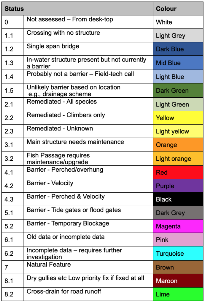
Output = Current Status

This is used for single span bridges or where there is no structure present but you want to record your visit.
It may also be used when access is difficult and will require further investigation at a later date.
The Quick Survey may not collect enough information to determine if the structure is a barrier to fish.
Used to capture all of the necessary attributes to describe the structure and to determine if the structure is a barrier to fish.
The Full Survey also collects other attributes that help with understanding the structure and immediate environment.
If fitted, fish passes are described as part of the full survey.
Used for structures that have already had the initial survey and need ongoing monitoring.
The Monitoring Survey also asks for a description of the fish pass and whether it requires maintenance.
The structure condition is also described to help with overall asset management.
Apart from “User Name” “Survey Type” and “Type of Structure” none of the questions are compulsory and you can move to the next screen by just clicking “Next”.
If you are unable to complete a question this may impact on the outputs when sorting data.
These attributes are automatically collected on all surveys when you press “Save”:
- Date
- Time
- Latitude
- Longitude
- Altitude
- Device ID
Quick Survey
| Initial Survey | RATIONALE |
| User_ID | Person collecting data |
| New_User_ID | New person not on list |
| Identified_Hazards | H&S |
| Name_of_Waterway | Location |
| Nearest_Road | Access |
| Structure_Marker | road marker if any |
| Type_Of_Structure | Structure type |
| Downstream_Structure_Photo | Records |
| Downstream_Photo | Records |
| Comments | information not covered above |
Full Survey
| Initial Survey | RATIONALE |
| User_ID | Person collecting data |
| Identified_Hazards | H&S |
| Name_of_Waterway | Location |
| Nearest_Road | Access |
| Structure_Marker | road marker if any |
| Type_Of_Structure | Structure type |
| Downstream_Structure_Photo | Records |
| Downstream_Photo | Records |
| Pipe_Format | age/quality – old non-socketed pipes become misaligned. Some councils have a program for replacement |
| Diameter_mm | Round culvertsCapacity, access |
| Thickness_mm | load bearing, fixings for mitigation |
| Culvert_Width_mm | box culverts, capacity assess |
| Culvert_Height_mm | box culverts, capacity assess |
| Length_Of_Bridge_m | Stream width. Risk management |
| Height_Of_Structure_m | Fish Barrier, Engineering, Risk management |
| Depth_Of_Cover_mm | Engineering, risk management |
| Gradient_Av_Ratio | Fish Barrier, hydrology |
| Gradient_Max_Ratio | Fish Barrier, hydrology |
| Structure_Material | Life expectancy, type of fixings for mitigation |
| Upstream_Waterway | Hydrology, habitat |
| Upstream_AddOns | Asset management, fish barrier |
| Fish_Observed_Upstream | Biodiversity |
| Upstream_Structure_Photo | Records |
| Upstream_Photo | Records |
| Stream_Bed_Material | Geology, habitat |
| Length_Of_Culvert_M | Fish barrier, access |
| Blockage | Asset management |
| Max_Length_Without_Bed_Material_M | Fish barrier. Indicates velocity barrier |
| Structure_Condition | Asset management. (RAMM protocol) |
| Culvert_Perch_Height_mm | Fish barrier |
| Culvert_Undercut_mm | Fish barrier |
| Tidal | Hydrology, habitat |
| Tidemark_mm | Hydrology, habitat |
| Flow_Rate_l_per_sec | Hydrology, habitat. Used to calculate Flow Rate. Also refer to culvert shape. Note round culvert with substrate may be treated as flat bottom (box) |
| Av_Velocity_M/sec | Fish Barrier, hydrology. Used with average depth and wetted width to calculate Flow Rate |
| Wetted_Width_Outlet_mm | Fish Barrier, hydrology. Used with average depth and wetted width to calculate Flow Rate. Remediation |
| Downstream_AddOns | Asset management, fish barrier |
| Water_State_Outside_Structure | Hydrology, habitat |
| Water state inside structure | Fish barrier, remediation |
| Depth_Of_Water_Inside_Culvert_mm | Hydrology, habitat, remediation |
| Water_Exits_Culvert_Into | Hydrology, habitat, remediation |
| Fish_Pass_Fitted | Fish barrier |
| Downstream_Waterway | Hydrology, habitat |
| Fish_Observed_Downstream | Biodiversity |
| Downstream_Structure_Photo | Records |
| Downstream_Photo | Records |
| Comments | information not covered above |
Monitoring Survey
| Initial Survey | RATIONALE |
| User_ID | Person collecting data |
| New_User_ID | New person not on list |
| Identified_Hazards | H&S |
| Name_of_Waterway | Location |
| Nearest_Road | Access |
| Structure_Marker | road marker if any |
| Type_Of_Structure | Structure type |
| Fish_Pass_Fitted | Fish barrier |
| Fish Passage ID | Location |
| Fish_Pass_Desc | Describe fish pass |
| Structure_Condition | Asset management. (RAMM protocol) |
| Culvert_Perch_Height_mm | Fish barrier |
| Max_Length_Without_Bed_Material_M | Fish barrier. Indicates velocity barrier |
| Downstream_Structure_Photo | Records |
| Comments | information not covered above |

